 Tally Wild
Thermal drone deer herd analysis
Know what's really on your ground. A thermal drone flies your whole property in a morning or evening and counts the bucks, does and predators it finds, so you can plan food plots, doe harvest and which bucks to let walk with real numbers instead of guesses.
Free. See the three closest pilots and message one. Drone pilot? Get on the map.
See the whole herd, not just the deer that walk past a camera
Deer give off heat, and a thermal camera sees that heat through the dark and through bare winter timber. From a few hundred feet up, a drone sees far more of a property in one flight than any number of trail cameras or a spotlight from the road.
The whole property in one flight
A drone covers hundreds of acres in a single morning or evening, including bedding areas, thickets and back corners you'd never walk into.
Bucks, does and fawns
Each animal is counted and sorted, so you get a buck-to-doe ratio, fawns per doe and deer per 100 acres for your land, not a statewide average.
Predators show up too
Coyotes, bobcats and hogs glow just as brightly as deer, so you see what's hunting your fawns.
No pressure on the deer
Flown at height, there's no walking the woods, no human scent and no spotlight sweeping the fields.
Numbers you can compare
Fly the same property next year and compare. You'll see whether your harvest plan is working.
Faster than a camera census
A trail camera census takes weeks of cards and guesswork. A drone count is done in a day and the report follows soon after.
Thermal drones count deer accurately
Wildlife researchers have tested thermal drones against deer herds where the number of animals was already known. Results depend on cover, weather and timing, which is why pilots fly cold mornings and evenings with the leaves down.
of a known deer herd counted on evening thermal drone flights in an Auburn University study.
Beaver et al., Wildlife Society Bulletin, 2020Drone estimates for white-tailed deer matched trail-camera and helicopter estimates on Texas ranches, and repeat drone flights were more consistent than repeat helicopter flights.
Wildlife Society Bulletin study reported by The Wildlife Society, 2024is how many marked deer were typically seen from helicopters in earlier research, the method drones are replacing.
Reported by The Wildlife Society, 2024From your property line to a finished report
Find a pilot
Search your zip code on the map and message a pilot near you about your acres and goals.
Plan the flight
The pilot maps your property line and picks a cold, clear morning or evening, ideally with the leaves down.
Fly and count
The drone flies back-and-forth lines over the whole property. Every buck, doe and predator is marked.
Get your report
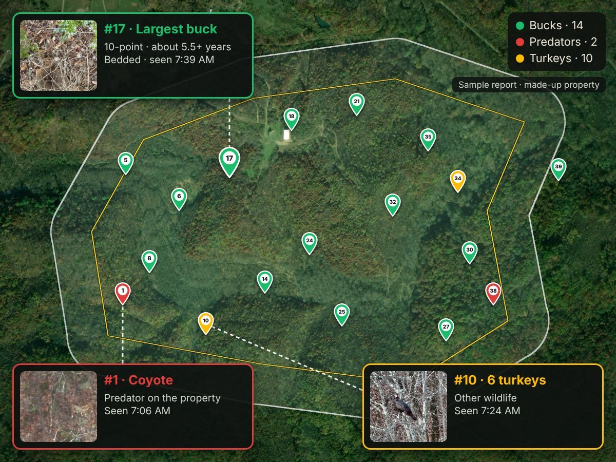
You get the counts, buck-to-doe ratio, fawn recruitment, deer per 100 acres, photos of your bucks and a map of where they were.
What a herd analysis tells you
- Total deer, bucks, does and fawns on your property
- Buck-to-doe ratio and deer per 100 acres
- Fawn recruitment (fawns per doe): whether your herd is replacing itself
- Photos of bucks with estimated points and age class
- Predators and other animals found, with counts
- A map of where animals were bedded or feeding, plus files for hunting apps like onX
- A harvest plan to discuss with your pilot that takes fawn recruitment into account (always within your state's seasons and bag limits)
Deer herd analysis near you
Thermal drone pilots on the map offer herd analysis for farms, hunting leases, clubs and private land. Search for pilots in Ohio, Kentucky, West Virginia, Indiana, Wisconsin and Virginia and across the US.
Deer herd analysis questions
How does a thermal drone count deer?
A thermal camera sees body heat. Flying a few hundred feet up in planned lines over the property, the pilot marks each animal that shows up warm against the cooler ground and sorts them into bucks, does, fawns and other animals.
When is the best time for a drone deer count?
Cold mornings and evenings from late fall through early spring, after the leaves drop. The bigger the difference between body heat and the ground, the easier deer are to see.
Can a drone tell bucks from does?
Yes, in most cases. Pilots fly a zoom camera over bucks to confirm antlers. Bucks that have shed their antlers late in winter can be harder to sort.
How many acres can be covered?
Hundreds of acres in a single flight session. Larger properties are flown over more than one session.
Is a drone better than trail cameras?
They work well together. Cameras show which deer pass one spot over weeks. A drone count shows the whole property at once and gives you a buck-to-doe ratio and density for your land.
Is flying deer with a drone legal?
Counting deer for management is different from hunting with a drone. Pilots need FAA Part 107 certification and the landowner's permission, and some states limit drone use around hunting season. Ask your pilot and check your state wildlife agency's rules.
What is fawn recruitment?
Fawn recruitment is how many fawns per doe made it through summer into fall and winter. It shows whether the herd is replacing itself. When it is low, the report suggests fewer does be taken and points to fawn survival: coyotes, fawning cover and summer food. It is best measured from a flight between August and February, when fawns are still smaller than does.
Sources: Beaver et al. 2020, Wildlife Society Bulletin · The Wildlife Society: drone study, 2024
Offer herd analysis? Get found by landowners
Landowners search the Find a Pilot map by zip code. Tally Wild subscribers are listed free with a herd analysis badge, and other drone pilots can list for $100 a year.